Questions & answers
What are the best access points for floating the Buffalo River?
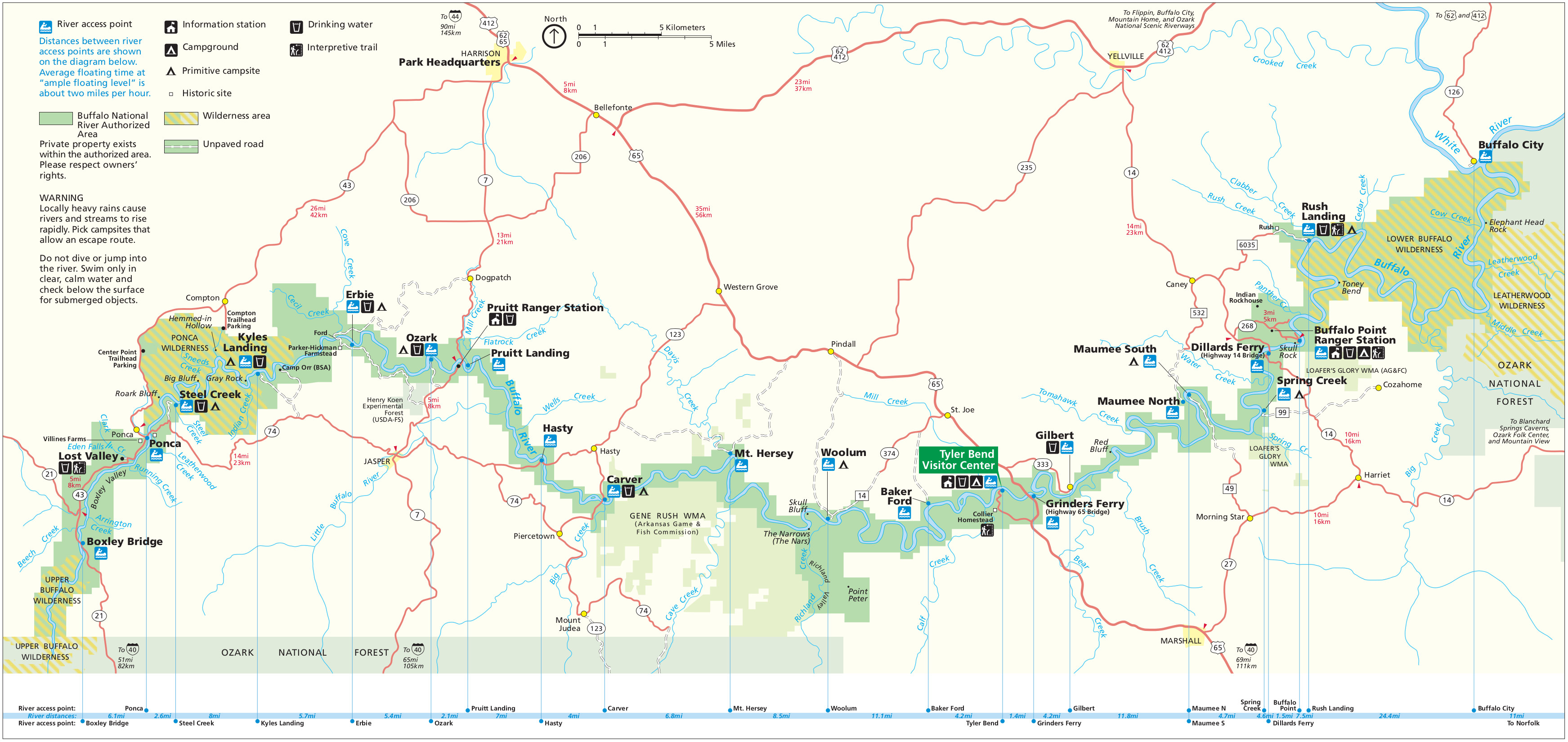
The best access points often depend on current water levels and your desired trip length. Popular spots include Ponca, Kyles Landing, Erbie, Pruitt, Carver, and Rush. Ponca is ideal for the upper, more challenging sections, while access points further downstream like Pruitt or Rush offer calmer floats, suitable for families. Always check river conditions before selecting your put-in.Do I need a map to float the Buffalo River?
Yes, a reliable map is highly recommended, if not essential, for floating the Buffalo River. Cell service is unreliable in many areas, rendering digital navigation useless without offline maps. A physical map helps you track river mileage, identify rapids, locate access points, and plan your take-out, ensuring a safer and more enjoyable experience. It's a key safety tool.Where can I get a free map of Buffalo National River?
While truly comprehensive, detailed maps usually require a purchase, you can often obtain basic recreational maps for free at National Park Service visitor centers along the Buffalo National River, such as the Tyler Bend Visitor Center or the park headquarters in Harrison. These free maps provide general overviews and highlight major access points.Are digital maps reliable on the Buffalo River?
Digital maps can be reliable if you download them for offline use *before* you lose cell service and carry a portable power bank. Apps like Gaia GPS or AllTrails with downloaded Buffalo River map layers work well. However, always carry a physical backup map. Technology can fail due to battery drain or water damage, making a paper map a crucial failsafe.What features should a good Buffalo River map include?
A quality Buffalo River map should include clear river mileage markers, all public access points, identified rapids and shoals, designated campgrounds, and hiking trailheads. Topographic contours are excellent for understanding terrain. Look for maps with waterproof capabilities for floating adventures, and always ensure the publication date is relatively current for accuracy.Embarking on a journey along the Buffalo River in Arkansas demands a reliable map to navigate its stunning wilderness safely and effectively. This comprehensive guide helps U.S. travelers, from seasoned adventurers to first-time visitors, pinpoint the ideal map for their specific needs, whether that's floating, hiking, or camping. We break down the differences between topographic, recreational, and digital maps, explaining crucial features like access points, rapids, campsites, and trailheads. Discover where to acquire the most current and detailed maps, including local outfitters, visitor centers, and online resources that cater specifically to the Buffalo National River experience. Learn how to interpret key map elements to plan your float trip, hike, or scenic drive, ensuring you make informed decisions about routes, estimated times, and potential challenges. Understanding your map is akin to having a local expert by your side, allowing you to compare various options and make the best choice for your unforgettable Arkansas adventure. Get ready to explore the natural beauty of the Buffalo River with confidence and clarity. We will help you understand why a quality map is not just a tool but an essential companion for your trip.
Frequently asked questions
What is the best type of map for floating the Buffalo River?
For floating the Buffalo River, a waterproof recreational map is ideal. These maps typically highlight river mileage, access points, rapids, and designated camping areas. They are designed to withstand water exposure, which is crucial for a river adventure, and help you gauge distances accurately between put-in and take-out spots.
Where can I buy a detailed map of the Buffalo National River?
Detailed maps of the Buffalo National River are available at local outfitters in towns like Ponca and Jasper, and at National Park Service visitor centers such as Tyler Bend. You can also find high-quality topographic maps from the USGS or National Geographic online, ensuring you get a comprehensive guide for your trip.
Are there any apps with Buffalo River maps for offline use?
Yes, several mapping applications offer offline map capabilities that are suitable for the Buffalo River, where cell service is limited. Popular choices include Gaia GPS and AllTrails. Remember to download the specific map layers for the Buffalo River area before you lose signal, and always carry a backup power source for your device.
How do I read a topographic map for Buffalo River hiking trails?
Reading a topographic map involves understanding contour lines, which represent elevation. Closely spaced lines indicate steep terrain, while widely spaced lines suggest a gentler slope. These maps also show trailheads, water features, and significant landmarks, helping you plan your hiking route and estimate elevation gains.
What are the main sections of the Buffalo River to consider for a trip?
The Buffalo River is generally divided into three main sections: the Upper (Ponca to Kyles Landing), the Middle (Kyles Landing to Rush), and the Lower (Rush to the White River confluence). The Upper section is known for its challenging rapids, while the Middle and Lower offer calmer waters, suitable for longer, more relaxed floats and family outings.
Is a map necessary if I only plan to visit the popular overlooks?
Even for visiting popular overlooks, a map of the Buffalo River Arkansas is beneficial. While GPS might guide you to main roads, a detailed map can highlight scenic turnoffs, hidden viewpoints, and nearby short trails that enhance your experience beyond just the main attractions. It helps you discover more of the area's beauty.
Planning an adventure along the stunning Buffalo River in Arkansas requires the right tools, and perhaps none are more crucial than a reliable map. This natural gem, America's first national river, offers unparalleled opportunities for floating, hiking, and immersing yourself in the Ozark wilderness. However, without a clear guide, navigating its winding waters and extensive trail systems can quickly become overwhelming.
Understanding which map best suits your plans is the first step towards a successful trip. Whether you are aiming for a multi-day float, a challenging hike, or simply want to locate prime scenic overlooks, having a detailed, up-to-date map of the Buffalo River Arkansas area is absolutely vital for safety and enjoyment.
| Map Type | Best For | Key Features |
|---|---|---|
| Topographic Map | Detailed terrain, elevation changes, experienced hikers | Contours, relief, water features, trails |
| Recreational Map | Floating, general recreation, camping, access points | River miles, rapids, campsites, put-ins/take-outs |
| Digital Map | Real-time location, navigation apps, emergency use | GPS integration, satellite imagery, downloadable offline |
| Local Outfitter Map | Specific trip sections, current conditions, rentals | Route advice, shuttle info, local tips |
Why is a Detailed Buffalo River Map Crucial for Your Trip?
A comprehensive map of the Buffalo River Arkansas is your personal guide to avoiding unexpected challenges and maximizing your enjoyment. The river's character changes dramatically from season to season and section to section, with varying water levels, rapids, and accessibility points. A good map provides essential information on these elements.
It also helps you accurately gauge distances and plan your itinerary, preventing you from overestimating your abilities or underestimating travel times. Imagine paddling past your intended take-out point in low light because you misjudged the distance—a detailed map helps prevent such mishaps. It truly ensures a smoother, safer experience for everyone involved.
Furthermore, navigating the Buffalo National River often means limited cell service in many areas. Relying solely on a smartphone for directions can leave you stranded without critical information when you need it most. A physical map or a robust offline digital map offers peace of mind when venturing into more remote sections of the park.
Being prepared with the right map means you can focus on the breathtaking scenery and unique wildlife, rather than worrying about getting lost. It transforms your journey from a potential stressor into a truly liberating exploration of nature's wonders. You will appreciate the foresight when you are out there.
| Map Feature | Importance | User Benefit |
|---|---|---|
| Access Points | Crucial for put-ins and take-outs | Easy entry and exit for floating |
| River Mileage | Estimates trip duration and distances | Accurate planning of daily travel |
| Rapids/Hazards | Identifies challenging sections | Safety awareness, preparation for rapids |
| Campsites | Locates designated overnight spots | Planned overnight stays, avoiding illegal camping |
| Trailheads | Shows starting points for hikes | Access to scenic hiking routes |
| Topography | Indicates elevation changes | Understanding terrain for hiking and views |
How to Choose the Best Map for Your Buffalo River Adventure
Selecting the right map for your Buffalo River Arkansas escapade depends heavily on your planned activities and comfort level with navigation. If you are primarily focused on floating, a recreational river map highlighting river miles, access points, and major rapids will be your best friend. These often have waterproof coatings, which is a huge plus on the water.
For serious hikers exploring the countless trails within the Buffalo National River area, a detailed topographic map is indispensable. These maps offer intricate elevation contours, showing every ridge, valley, and slope, which is critical for understanding terrain difficulty and planning routes. They provide a deeper understanding of the landscape you're traversing.
Many experienced visitors combine physical maps with digital alternatives. Downloadable maps for GPS-enabled devices or mapping apps can provide real-time location tracking, which is invaluable when double-checking your position or in low visibility conditions. Just remember to download them before you lose service and carry a backup power source.
Ultimately, the best map provides the specific details you need to confidently navigate your chosen adventure. Consider what information is most critical for your safety and enjoyment, and then seek out maps that excel in those areas. A little research upfront goes a long way toward a memorable trip.
| Essential Gear to Pair with Your Map | Why It Matters | Benefit to User |
|---|---|---|
| Waterproof Bag/Case | Protects physical maps from moisture | Preserves map readability in all conditions |
| Compass | Aids in orienting paper maps | Confirms direction, enhances navigation skills |
| GPS Device/Smartphone with Offline Maps | Provides real-time location data | Backup navigation, precise positioning |
| Power Bank | Keeps digital devices charged | Ensures digital maps remain accessible |
| Headlamp/Flashlight | Illuminates map in low light | Safe navigation during dawn, dusk, or night |
| First-Aid Kit | Addresses minor injuries | Preparedness for unexpected medical needs |
Where Can I Find Reliable Buffalo River Arkansas Maps Near Me?
Finding a quality map for the Buffalo River Arkansas is easier than you might think, especially if you know where to look. Official National Park Service (NPS) visitor centers, like the Buffalo National River headquarters in Harrison or the Tyler Bend Visitor Center, are excellent starting points. They often provide free basic maps and sell more detailed topographic or recreational versions.
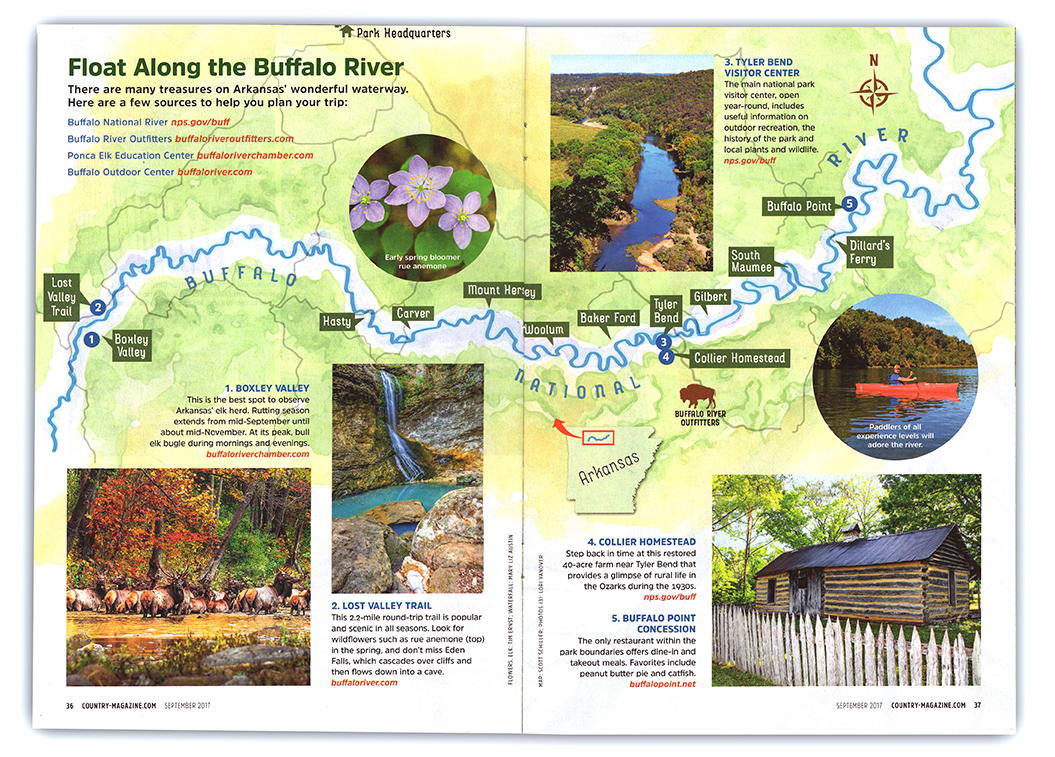
Local outfitters scattered along the river, in towns such as Ponca, Jasper, and St. Joe, are another fantastic resource. These businesses specialize in Buffalo River adventures and typically stock the most popular and up-to-date maps, often with their own branding or specific recommendations. Plus, their staff can offer invaluable local insights.
For those who prefer to plan ahead from home, various online retailers and mapping companies offer a wide selection. Look for reputable brands like National Geographic Trails Illustrated maps, or those produced by the U.S. Geological Survey (USGS) for detailed topographic data. Always check the publication date to ensure you're getting the most current information available.
Planning Your Route Using a Buffalo River Map
Once you have your Buffalo River map in hand, the real planning begins. Start by identifying your desired put-in and take-out points, paying close attention to river miles indicated on the map to estimate your float duration. Consider any rapids or challenging sections marked, and assess if they match your skill level and vessel type. For hikers, identify trailheads and use contour lines to understand elevation changes and potential steep climbs.
Always consult your map to locate designated campsites or primitive camping areas if you plan an overnight stay. Understanding where services like potable water or restrooms might be available is also key. Factor in potential shuttle routes if you're floating, as coordinating transportation between access points is a major logistical consideration. A solid plan ensures you enjoy every moment.
What Should I Know About Buffalo River Map Features?
A good map of the Buffalo River Arkansas isn't just lines and symbols; it's a treasure trove of information. Topographic lines show elevation, which is crucial for hikers to understand the terrain's difficulty. River miles help floaters track their progress and identify their position relative to access points and hazards. Clearly marked rapids and shoals allow you to anticipate challenges.
You will also find symbols for campgrounds, restrooms, scenic overlooks, and points of interest like historic sites or natural springs. These details enrich your trip, guiding you to places you might otherwise miss. Don't overlook the map's legend; it's the key to unlocking all the information embedded within its design. Spend a few minutes studying it before you head out.
In essence, whether you're a seasoned paddler or a first-time visitor, a detailed map for the Buffalo River Arkansas is more than just a piece of paper or a screen display. It's your indispensable companion for a safe, informed, and truly memorable adventure in one of America's most cherished natural landscapes. Equip yourself wisely, and let the Buffalo National River reveal its wonders.
Key highlights
Buffalo River map details, Arkansas National River access, floating Buffalo River routes, hiking Buffalo River trails, Buffalo National River camping spots, best maps near me, what map to use, Buffalo River trip planning, map features explained, local outfitters Arkansas, digital maps Buffalo River, paper maps comparison
Gallery


Tips For Booking A One Day Kayak Trip On The Stunning Buffalo River In E26793 383f3f48de404ae387039e589f640607mv2 E26793 383f3f48de404ae387039e589f640607mv2 How To Float Arkansas Complete Guide National Map Directions U S Park Service BUFF Maps Npmaps Com Just Free Period Area Highlighted Red Is This Pa Flickr 602042801 2CA535575C Z 602042801 2CA535575C Hiker Paradise New Mile Extension Of Trail 0403BUFFALORIVER T1000 0403BUFFALORIVER T1000 Searcy County Trails Hiking AR 800 Watershed 002 230610 800 002 230610 Waterfalls Ozark 6DC5C545FEB2F12AC817C4116224FA4B Sites 987585A4AA651E6005B6180026CBAE0D Best Alltrails Parks Us 10119435 20180801101840 10119435 20180801101840.


19951028 Fall Trip To Arkansas Day 19951028 Buffaloriverparkmap 19951028 Lower Buffalo National River BUFFALOMAP306 Maps By Scottbuffalo Scott Buffalorivermap Page Schedules Prescribed Burn In Wilderness PICTURE12 Best Trails Alltrails Parks Us 10119435 20200415080048000000000 10119435 20200415080048000000000 Tourist Map Photos Lontgrouptravel Com BUFFALOMAP02 Carte De Randonn E N 232 West Of 232 Geographic Pliee 515497 232 515497 Prepares For 2024 Eclipse Outside Upper District Paddling U S Park Buffparkmap UBD Poster Muir Way BA7740C8A66B49B247D2FF8D1C684714 Service Avenza 20211117160821 BUFF WM Preview 20211117160821 Buffaloriver.


Buffalo River Maps Npmaps Com Just Free Period Kyles Landing Erbie Trail Map Current National Levels Outdoor Center Store Waterfront Property On Arkansas At Bob Bormann Blog Cover Dirst Canoe Rental Float Trips Cabin White Rileys Outfitter 5B419CBB 5d44 4CEB A2F2 CA2C29EF2A2C 5B419CBB 5d44 4CEB A2F2 CA2C29EF2A2C 20231030 Buffalonationalriver Fallcolor WJN 009 Opt 20231030 009 2026 Park Unigrid Brochure NPS S L400 395634 3903 Medium 3903 Let The Be A History Of Ozark FIG1 Hike An In Depth Guide To Woolum Dillards 5f00e234 D994 4663 9F5E945910E1E54A 5f00e234 D994 4663 9F5E945910E1E54A Ponca Right Kind Lost 2E0B8433F1E939F23EAF86241EE961EF.