Locating the International Date Line on a map is essential for anyone interested in global geography, international travel, or understanding time zones. This critical, imaginary boundary in the Pacific Ocean marks where one calendar day transitions into the next. For U.S. searchers, understanding its path is key for planning journeys to Asia or Oceania, where crossing the line can mean gaining or losing an entire day. Many travelers rely on world maps to pinpoint its exact, zigzagging course, which often deviates from the 180 degree longitude to accommodate various island nations and political boundaries. This helps prevent countries from being split into two different calendar days, avoiding significant administrative and social confusion. Discover detailed maps that highlight this geographical phenomenon, learn its historical context, and grasp its profound implications for international shipping, communication, and scheduling. This guide helps you navigate its complexities and confidently plan global interactions.
What is the International Date Line's exact location?
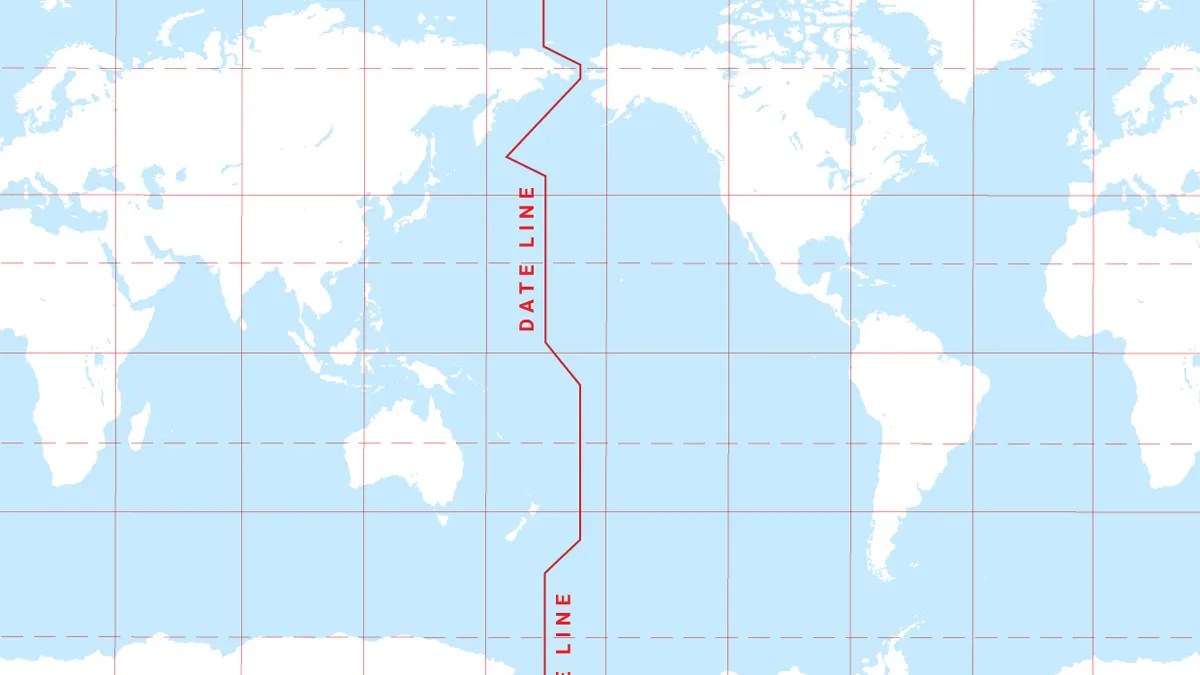
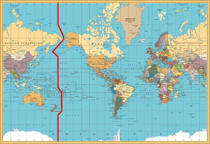
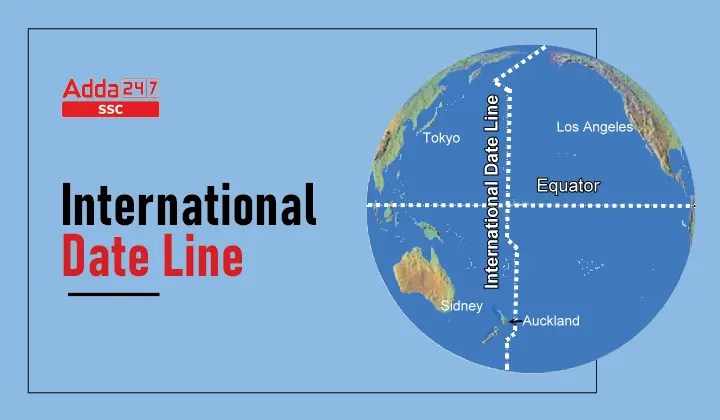
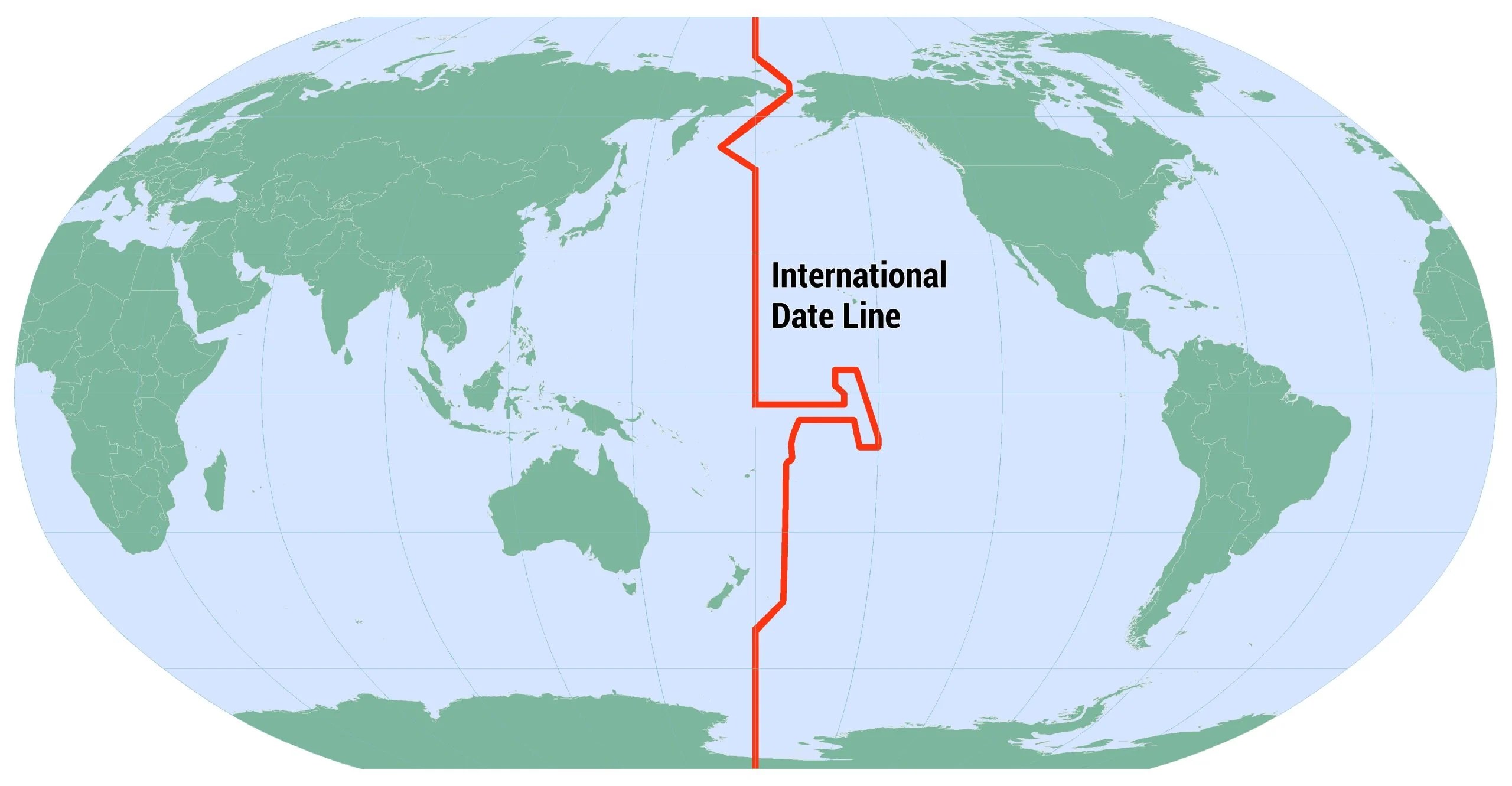
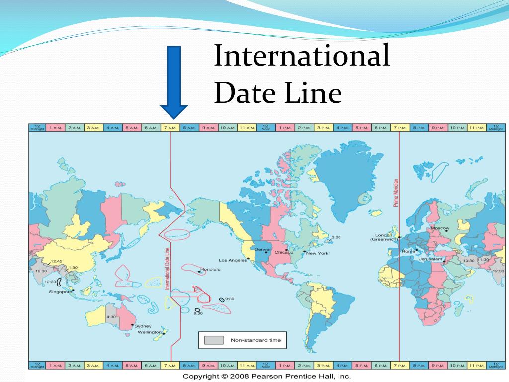
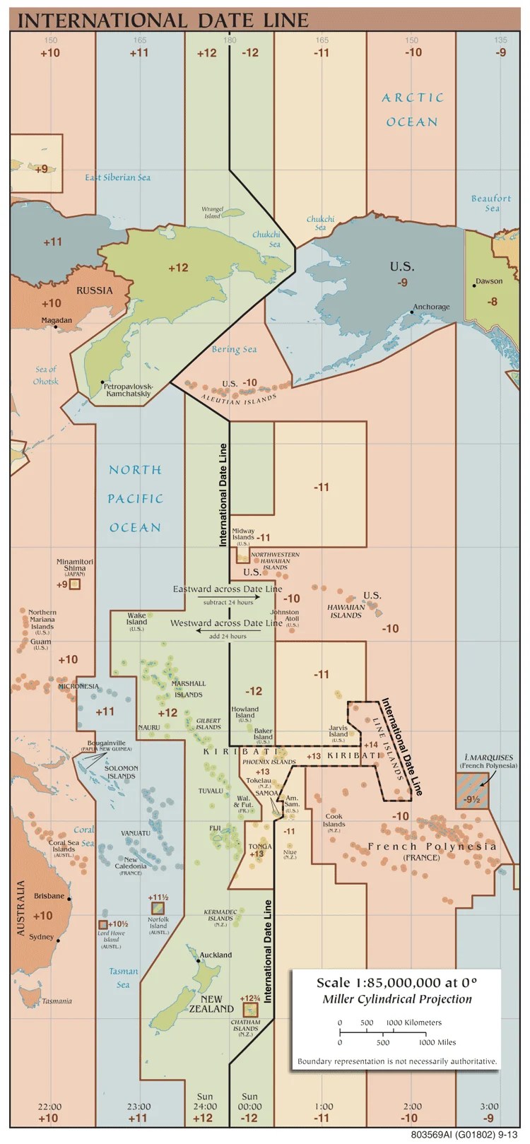
The International Date Line primarily follows the 180 degree longitude line in the Pacific Ocean. However, it deviates around various island nations and political boundaries, like Kiribati and Samoa, to keep entire countries within the same calendar day for administrative and economic consistency. This ensures a uniform date across these territories.
Why does the International Date Line zigzag?
The International Date Line zigzags to avoid splitting countries or island groups into two different calendar days. This practical adjustment prevents confusion for local populations, businesses, and government operations. For example, it shifts eastward around Kiribati and westward around Samoa to accommodate their preferred time zones, ensuring national unity in dating.
What countries are affected by the International Date Line?
Many Pacific island nations are directly affected, including Kiribati, Samoa, Tonga, and Fiji. Russia and the United States (via Alaska's Aleutian Islands) also lie on opposite sides of the line, though their mainland territories are not directly bisected. Its primary impact is on international travel and communication schedules crossing the Pacific.
How does the International Date Line impact air travel?
Air travelers crossing the International Date Line either gain or lose a calendar day. Flying west from the Americas to Asia, you "lose" a day, skipping forward. Flying east from Asia to the Americas, you "gain" a day, repeating one. This crucial shift requires careful itinerary planning to avoid scheduling errors and confusion.
Is the International Date Line a real physical line?
No, the International Date Line is an imaginary line on Earth's surface. It has no physical manifestation like a fence or marker. It exists purely as a convention, a globally agreed-upon demarcation point to signify where one calendar day ends and the next begins. Maps represent it with a dotted or dashed line for clarity.
Where to Find the International Date Line on a Map?The International Date Line, an invisible yet profoundly significant marker, dictates when one calendar day ends and another begins across the globe. Understanding its placement on a map is crucial for travelers, businesses, and anyone engaged with international affairs. This line, primarily situated in the Pacific Ocean, is not a straight boundary but shifts and zigs to maintain consistency for various countries.
For those in the United States, comprehending the International Date Line's location on a map becomes especially relevant when planning trips or conducting business with regions across the Pacific. It directly impacts scheduling, travel times, and even how you mark dates on your calendar when journeying to places like Asia, Australia, or numerous Pacific island nations. Finding this line on a reliable map allows for accurate planning.
Understanding the International Date Line
What is the International Date Line?
The International Date Line (IDL) is an imaginary line on Earth's surface that runs approximately along the 180 degree line of longitude, primarily through the Pacific Ocean. It serves as the official demarcation where the date changes by one day. Crossing it from east to west advances your calendar by a day, while crossing from west to east sets it back a day.
This critical boundary ensures that the calendar day remains consistent globally, preventing scenarios where adjacent territories might otherwise experience different dates simultaneously. Without the IDL, determining the correct date in various parts of the world would lead to widespread confusion, especially for international commerce and travel coordination.
While invisible to the naked eye, the IDL is prominently displayed on world maps to help people visualize this essential timekeeping convention. Its existence simplifies global scheduling and helps maintain a universally accepted system for time and date. Navigators and travelers rely on maps to understand its precise location and implications.
Why Does the International Date Line Exist?
The International Date Line was established out of necessity as global exploration and travel became more common. Sailors and explorers, circumnavigating the globe, found themselves a day off upon returning home, depending on their direction of travel. This discrepancy highlighted the need for a universally recognized point where a new day formally begins.
Its existence resolves the dilemma of defining where one day ends and the next begins. Without a designated line, there would be no consistent point for changing calendar dates, leading to continuous confusion for international communication, trade, and travel schedules. The IDL provides this essential, agreed-upon reference point.
The line ensures that as the Earth rotates and different time zones progress, there is a clear, international understanding of the current date. This global convention maintains order in our calendars, making synchronized activities across different parts of the world possible and preventing chronological chaos for everyone.
Locating the International Date Line on World Maps
Where to See the International Date Line Clearly
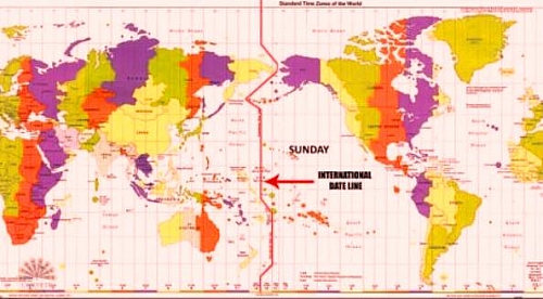
To locate the International Date Line, look for a prominent, often dashed or dotted, line running down the middle of the Pacific Ocean on a world map. It typically follows the 180 degree longitude, but you will notice significant deviations around landmasses and island groups. These shifts are intentional, designed to keep entire nations on the same calendar date.
High-quality physical atlases and digital mapping services like Google Maps or specialized time zone maps will clearly mark the IDL. Pay close attention to how it bends around countries such as Kiribati and Samoa. These adjustments, made for practical administrative and economic reasons, are crucial details for anyone needing precise date line information.
Whether you are using a wall map for general reference or a digital map for detailed travel planning, identifying the IDL is straightforward once you know what to look for. Its visual representation provides immediate clarity on where global dates shift, helping travelers and planners anticipate calendar changes as they cross the vast Pacific expanse.
Practical Implications for U.S. Travelers
For U.S. citizens traveling internationally, especially to destinations in Asia, Australia, or the Pacific Islands, understanding the International Date Line's location is critically important. Crossing this line directly impacts your travel schedule, as you will either gain or lose a day, depending on your direction of flight. This calendar shift requires careful itinerary planning.
When flying westward from the U.S. to countries like Japan or New Zealand, you will typically
International Date Line map location, find International Date Line on world map, how the International Date Line works, Pacific Ocean date line map, crossing the International Date Line, understanding global time zones


Date Line Worksheet Map Date Line . Today S Date And Time Current Date Time More Date Line.webp. Date Line Degrees 1543399075 Internatinl Date Line Map . Time To Get In The Zone Educational Resources K12 Learning Earth Date Line 13119 . Date Line IDL Date Line


My Library I D L Date Line Date Line . Time Zone Comparison Time Zone Map Standard Time Date Line . 1 World Geography MR PARNELL 4 Date Line Orig . Date Line Definition Map Importance Facts Britannica Time Zone Map Standard Time Date Line . Date Line Date Line Pdf NTQIR Date Line 01



GREENWICH MEAN TIME AND DATE LINE YouTube . Where Is The Date Line Earth How Date Line World Map Scaled . Date Line Geography From Classroom To Campus Date Line 1 1024x576 . Day Night Line On Earth Map Of Daytime And Nighttime TZXPTR World Map Date Line . Closest Country To The Date Line Samoa S Unique Time Date Line Map 850x850


PPT AP HUMAN GEOGRAPHY PowerPoint Free Download ID Slide13 L . Date Line On A World Map . Global Map Showcasing Regions With Number Tiles The Year Global Map Showcasing Regions Number Tiles Year Global Map Showcasing Regions Number Tiles 418812709 . Date Code Date Formats List KCWDH Date Line N . Date Line Map And Explanation Nghistory 2212 Nye Time Zones Primary Ai2html X Small Or Mobile


Ano Ang Date Line . GEOGRAPHY Grand Test 2026 UPSC Prelims Online MCQ Test 2026 KPIAS Word Image 48241 2 27 . World Map 2026 Defacto Borders Stock Photos Free Royalty Free Stock Future Planning Wooden Blocks Showing Map Asia Europe Concept 419099971 . 2026 Future Timeline On World Map Background 2026 Global Forecast And 1000 F 1872704233 . World Map And Year 2026 Of The World Map With The Year 1000 F 1754974276

.jpg)


2026 World Map A Stylized World Map Video Overlaid With 1000 F 1755037871 . Date Hellfest 2026 Svg Calendar Month Year De Time Zones Small (2007) . World Map 2026 Defacto Borders Stock Photos Free Royalty Free Stock Wooden Blocks Displaying Year Positioned World Map Wooden Blocks Displaying Year Positioned World Map Showcasing 418434704 . New Year 2026 Began Today In Australia Other Countries Here Are Maps 87970420007 Screenshot 20251231 At 91519 Am . Date Line Map And Explanation Map Of The Pacific



World Date Line Map At Timothy Kawamoto Blog Stock Vector Earth Map With Date Line Clipart 19816 . World Map Date Line Date Line . PPT Tourism Destination Information PowerPoint Free Date Line L . Glowing World Map The Year 2026 Across Continents Stock Glowing World Map Year Across Continents Luminous Showcases Prominently Displayed All Dots Forming 424975802